The history of the invention of the compass briefly. Abstract: Compass, the history of its discovery
Abstract on the topic:
"Compass, the history of its discovery"
Performed:
Student 8 "B" class
MOU "SOSH" №90
Brusova Anna.
Checked:
Valentina Vasilievna Pchelintseva
Chrysostom 2010
COMPASS, a device for determining horizontal directions on the ground. It is used to determine the direction in which the sea, aircraft, ground vehicle is moving; the direction in which the pedestrian is walking; directions to some object or landmark. Compasses are divided into two main classes: magnetic compasses such as arrows, which are used by topographers and tourists, and non-magnetic, such as a gyrocompass and a radio compass.
SPANISH MARITIME COMPASS, 1853
Compass card. To determine the directions in the compass, there is a card (Fig. 1) - a circular scale with 360 divisions (corresponding to one angular degree each), marked so that the countdown is from zero clockwise. North (north, N, or C) usually corresponds to 0, east (east, O, E, or B) - 90, south (south, S, or S) - 180, west (west , W, or Z) - 270. These are the main compass points (countries of the world). Between them are "quarter" points: northeast, or northeast (45), southeast, or southeast (135), southwest, or southwest (225) and northwest , or NW (315). Between the main and quarter are 16 "main" points, such as the north-north-east and north-north-west (there were once 16 more points, such as the "north-shadow-west", simply called the points).
MAGNETIC COMPASS
Operating principle. In the device indicating the direction, there must be some reference direction, from which all others would be counted. In a magnetic compass, this direction is the line connecting the North and south pole Earth. In this direction, the magnetic rod settles by itself if it is suspended so that it can freely rotate in a horizontal plane. The fact is that in the Earth's magnetic field, a rotating pair of forces acts on the magnetic rod, setting it in the direction magnetic field. In a magnetic compass, the role of such a rod is played by a magnetized needle, which, when measured, itself is set parallel to the Earth's magnetic field.
Arrow compass. This is the most common type of magnetic compass. It is often used in a pocket version. In the arrow compass (Fig. 2) there is a thin magnetic needle mounted freely at its midpoint on vertical axis, which allows it to rotate in a horizontal plane. The northern end of the arrow is marked, and a card is fixed coaxially with it. When measuring, the compass must be held in your hand or mounted on a tripod so that the plane of rotation of the arrow is strictly horizontal. Then the north end of the arrow will point to the earth's north magnetic pole. A compass adapted for topographers is a direction-finding device, i.e. azimuth measuring instrument. It is usually equipped with a spotting scope, which is rotated until aligned with the desired object, in order to then read the azimuth of the object from the card.
Liquid compass. The liquid compass, or floating card compass, is the most accurate and stable of all magnetic compasses. It is often used on ships and is therefore called a ship. The designs of such a compass are varied; in a typical variant, it is a “pot” filled with liquid (Fig. 3), in which an aluminum card is fixed on a vertical axis. On opposite sides of the axis, a pair or two pairs of magnets are attached to the bottom of the card. In the center of the card there is a hollow hemispherical protrusion - a float that weakens the pressure on the axle support (when the pot is filled with compass fluid). The axis of the card, passed through the center of the float, rests on a stone bearing, usually made of synthetic sapphire. The thrust bearing is fixed on a fixed disk with a "heading line". There are two holes at the bottom of the pot through which liquid can overflow into the expansion chamber, compensating for changes in pressure and temperature.
Rice. 3. LIQUID (SHIP) COMPASS, the most accurate and stable of all types of magnetic compass. 1 - holes for overflowing the compass liquid when it expands; 2 - filling plug; 3 - stone thrust bearing; 4 - the inner ring of the universal joint; 5 - a card; 6 - glass cap; 7 – heading marker; 8 - the axis of the card; 9 - float; 10 – course line disk; 11 – magnet; 12 - bowler hat; 13 - expansion chamber.
The card floats on the surface of the compass liquid. The liquid, moreover, soothes the vibrations of the card caused by rolling. Water is not suitable for a ship's compass, as it freezes. A mixture of 45% ethyl alcohol with 55% distilled water, a mixture of glycerin with distilled water, or a high-purity petroleum distillate is used.
The bowler hat of the compass is cast from bronze and is equipped with a glass cap with a seal that excludes the possibility of leakage. An azimuth, or direction-finding, ring is fixed in the upper part of the bowler. It allows you to determine the direction to various objects relative to the course of the vessel. The compass bowler is fixed in its suspension on the inner ring of the universal (cardan) hinge, in which it can freely rotate, while maintaining a horizontal position, in pitching conditions.
The compass bowler is fixed so that its special arrow or mark, called the course line, or a black line, called the course line, points to the bow of the vessel. When the ship's heading changes, the compass card is held in place by magnets, which invariably maintain their north-south direction. By shifting the course mark or line relative to the card, you can control course changes.
LIQUID COMPASS
COMPASS CORRECTION
The compass correction is the deviation of its readings from the true north (north). Its causes are the deviation of the magnetic needle and magnetic declination.
Deviation. The compass points to the so-called. compass, and not to magnetic north (magnetic north pole), and the corresponding angular difference in directions is called deviation. It is due to the presence of local magnetic fields superimposed on the Earth's magnetic field. The local magnetic field can be created by the ship's hull, cargo, large masses of iron ores located near the compass, and other objects. The correct direction is obtained by taking into account the deviation correction in the compass readings.
Ship magnetism. Local magnetic fields created by the ship's hull and covered by the concept of ship's magnetism are divided into variable and constant. Variable ship magnetism is induced in the ship's steel hull by the Earth's magnetic field. The intensity of the ship's alternating magnetism varies depending on the course of the ship and on geographical latitude. Permanent ship magnetism is induced during the construction of the ship, when under the influence of vibration caused, for example, by riveting operations, the steel skin becomes a permanent magnet. The intensity and polarity (direction) of the ship's permanent magnetism depend on the location (latitude) and orientation of the ship's hull during its assembly. Permanent magnetism is partly lost after the ship is launched into the water and after it has been in rough seas. In addition, it changes somewhat during the “aging” of the hull, but its changes are significantly reduced after the vessel has been in operation for a year.
Ship magnetism can be decomposed into three mutually perpendicular components: longitudinal (relative to the ship), transverse horizontal and transverse vertical. Deviations of the magnetic needle due to the ship's magnetism are corrected by placing near the compass permanent magnets parallel to these components.
Binnacle. The ship's compass is usually mounted in a universal joint on a special stand called a binnacle (Fig. 4). The binnacle is rigidly and securely attached to the deck of the vessel, usually on the center line of the latter. Magnets are also installed on the binnacle to compensate for the influence of ship magnetism, and a protective cap for the compass with an internal card illuminator is fixed. Previously, the binnacle was made in the form of a carved wooden figure, but on modern ships it is just a cylindrical stand.
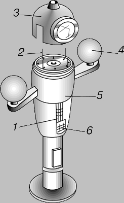
Rice. 4. Binnacle, stand for a ship's compass. Quarter spheres and a course magnet compensate for the effect of the ship's magnetism. 1 - course magnet; 2 – course line marker; 3 - protective cap; 4 - quarter sphere; 5 - bowler compass; 6 - magnets.
Magnetic declination. Magnetic declination is the angular difference between the magnetic and true north, due to the fact that the magnetic north pole of the Earth is shifted by 2100 km relative to the true, geographical one.
Declination map. Magnetic declination varies over time and from point to point on earth's surface. As a result of measurements of the Earth's magnetic field, declination maps were obtained, which give the magnitude of the magnetic declination and the rate of its change in different areas. The contours of zero magnetic declination on such maps, emanating from the north magnetic pole, are called agonic lines or agons, and the contours of equal magnetic declination are called isogonic or isogons.
Compass correction. Currently, a number of different methods of accounting for compass corrections are being used. All of them are equally good, and therefore it is enough to give as an example only one adopted by the US Navy. Deviations and magnetic declinations to the east are considered positive, and to the west - negative. Calculations are made according to the following formulas:
Magn. e.g. Comp. e.g. Deviation,
Comp. e.g. Mag. e.g. Declination.
Kozhukhov V.P. and etc. Magnetic compasses. M., 1981
Nechaev P.A., Grigoriev V.V. Magnetic compass business. M., 1983
Degterev N.D. Arrow magnetic compasses. L., 1984
Report on the topic:
"Compass, the history of its discovery"
2017
Compass (in the professional speech of sailors: compass) is a device that facilitates orientation in the area. There are three fundamental different kind compass: magnetic compass, gyro compass and electronic compass.
History of creation
Presumably, the compass was invented in China in 2000 BC. e and was used to indicate the direction of movement through the deserts. In Europe, the invention of the compass dates back to the 12th-13th centuries. , however, its device remained very simple - a magnetic needle mounted on a cork and lowered into a vessel with water. In the water, the cork with the arrow was oriented in the right way. At the beginning of the XIV century. the Italian F. Joya significantly improved the compass. He put a magnetic needle on a vertical pin, and attached a light circle to the arrow - a coil, divided around the circle into 16 points. In the XVI century. they introduced the division of the coil into 32 points and the box with the arrow began to be placed in a gimbal suspension in order to eliminate the effect of the ship's pitching on the compass. In the 17th century the compass was equipped with a direction finder - a rotating diametral ruler with sights at the ends, strengthened by its center on the lid of the box above the arrow.
Compass, a device for determining horizontal directions on the ground. It is used to determine the direction in which the sea, aircraft, ground vehicle is moving; the direction in which the pedestrian is walking; directions to some object or landmark. Compasses are divided into two main classes: magnetic compasses such as arrows, which are used by topographers and tourists, and non-magnetic, such as a gyrocompass and a radio compass.
Spanish nautical compass - 1853
Compass card. To determine the directions in the compass, there is a card - a circular scale with 360 divisions (corresponding to one angular degree each), marked so that the countdown is from zero in a clockwise direction. North (north, N, or C) usually corresponds to 0, east (east, O, E, or B) - 90, south (south, S, or S) - 180, west (west , W, or Z) - 270. These are the main compass points (countries of the world). Between them are "quarter" points: northeast, or northeast (45), southeast, or southeast (135), southwest, or southwest (225) and northwest , or NW (315). Between the main and quarter are 16 "main" points, such as the north-north-east and north-north-west (there were once 16 more points, such as the "north-shadow-west", simply called the points).
Magnetic compass.
Operating principle. In the device indicating the direction, there must be some reference direction, from which all others would be counted. In a magnetic compass, this direction is the line connecting the North and South Poles of the Earth. In this direction, the magnetic rod settles by itself if it is suspended so that it can freely rotate in a horizontal plane.
Arrow compass. This is the most common type of magnetic compass. It is often used in a pocket version. The arrow compass has a thin magnetic needle mounted freely at its midpoint on a vertical axis, which allows it to rotate in a horizontal plane. The northern end of the arrow is marked, and a card is fixed coaxially with it. When measuring, the compass must be held in your hand or mounted on a tripod so that the plane of rotation of the arrow is strictly horizontal. Then the north end of the arrow will point to the earth's north magnetic pole. A compass adapted for topographers is a direction-finding device, i.e. azimuth measuring instrument. It is usually equipped with a spotting scope, which is rotated until aligned with the desired object, in order to then read the azimuth of the object from the card.
It is known that no inventions of human art have ever been
brought more benefit to the human race than this compass.
V. Gilbert
AT THE ANCIENT CRADLE OF THE COMPASS
The role of the magnetic compass in the development of navigation is difficult to overestimate. This is an amazing device. Its history goes back to ancient times, the present is very impressive - not a single ship going to sea can do without it, and the future is seen in its further improvement and expansion of the boundaries of application.
The compass not only helped navigators, but also gave impetus to the development of the doctrine of the Earth's magnetic field, contributed to the discovery of the relationship between magnetic and electric fields, many branches of science began with it. In other words, the magnetic compass not only “discovered the globe”, it opened the physical world to humanity.
The most advanced scientists of their time contributed to the study and improvement of the magnetic compass. The theory of the compass and the methods of its use were studied by W. Gilbert and G. Coulomb, A. Humboldt and K. Gauss, A. Euler and M. Lomonosov, H. Oersted and A. Krylov and many others.
The honor of the invention of the compass is disputed by the Chinese and Indians, Arabs and Italians, French and British. Many studies are devoted to the history of this device, but their results and conclusions are not uniform. The contradictions and inaccuracies encountered can be largely explained by the fact that documents and evidence of the distant past have not reached us and many conclusions are made only on assumptions, and in part by the fact that the researchers were historians, archaeologists, geologists, physicists, writers and, unfortunately, sailors are much less common, which could not but leave its mark on the views and assessment of discoveries.
There are various versions about the origins of the invention of the compass. The most common of them - the compass was invented in China in 3000-2500. BC e. and from there he came to Europe.
Tsy-shi (stone maternal love) - so called in ancient China pieces of brown ore, which has the property of attracting and holding light pieces of iron.
The Chinese drew attention to the fact that such a stone also has another amazing property: if you give it an elongated shape and hang it on a thread, it is set with one end in the direction to the north (towards the North Star), and the other - to the south. Deviated from this equilibrium position, after several oscillations, it is again set to its original position. This property of the qi-shi stone to indicate the direction led travelers through the endless deserts of the Gobi to use it for orientation when neither the Sun nor the stars were visible. Here is how it is recorded in an ancient Chinese chronicle:
“... Caravans are moving along the endless sands of the Gobi desert. The sun is hidden by a yellow veil of dust. Far from the banks of the Yangtze to the Kushan kingdoms, and there are no visible well-trodden paths to them. It is difficult, oh, how difficult it would be for the caravaners if they did not take with them a white clay pot, which they cherish more than all their expensive goods, although there is neither gold, nor pearls, nor ivory in it. In a vessel on a wooden float lies a brown stone that loves iron. Turning around, he always points the way to the south for travelers, and this, when the Sun is closed or the stars are not visible, saves them from many troubles, leading them to the wells and directing them along the right path.
If we believe the ancient chronicles, then it is this clay pot with tsy-shi that should, apparently, be considered the first prototype of the compass.
However, in popular science and often in special literature, the first compass is taken to be the invention of the chi-nana - the pointer to the south. From one book to another, a version travels that in ancient China, two-wheeled horse-drawn carts of jinanche were known with figures of a person with an outstretched arm mounted on them. Figurine made of jade, about 40 centimeters high,
decorated with graceful patterns, was installed on the front of the chariot and, thanks to the magnet allegedly built into it, always faced south. Such chariots with a “pointer to the south”, according to the book “Ku-kengzhu” (“Explanation of old and new facts”) by a certain Zui Bao, helped Emperor Huangti in 2364 BC. e. in dense fog and clouds of dust, defeat your opponent ZhiSu.
Many people believed in the possibility of controlling the figure with a magnet, including such an authority as the famous shipbuilder Academician A. N. Krylov. It is to the indications of this fact that A. N. Krylov most often refers to the majority of authors of works devoted to the history of the magnetic compass. However, studies of recent decades have shown that the “Guiding Cart” of the ancient Chinese has nothing to do with the magnetic compass.
According to ancient Chinese documents, it was possible to establish that the mechanism of action of the figurine is based on a system of gears, with the help of which the figurine was connected to the wheels of the wagon. Before setting off on a journey, the figurine was exposed so that the outstretched hand pointed to the south. When turning, the figurine kept its position, and the change in direction of movement was determined by the deviation of the wheels.
The Sun, stars and other landmarks were used to set the initial position. True, the famous Russian geographer A. A. Tillo claims that they established the initial position of the wagon by a magnetic needle, which floated in a vessel of water carried behind the wagon. However, he does not provide any evidence for his assertion.
On ships, according to some ancient Chinese literary sources, the use of a magnet to determine the cardinal points began to be used much later - somewhere between 400 and 300 years. BC e. It was called chi-nan-tin and was an iron needle rubbed with a magnetic stone, that is, a magnetized iron needle, suspended on a thin thread of untwisted silk. Such a compass, allegedly, was used by eastern sailors. But this is also questionable.
If the compass in China began to be used on ships as early as the 4th-3rd centuries. BC e., why didn’t he penetrate Europe already then? After all, since the beginning of the 7th century. BC e. merchant ships from distant India began to visit Chinese ports regularly, and to India already in the 2nd century. BC e. the Greeks sailed, who at the beginning of our millennium themselves penetrated into the South China Sea. It is unlikely that such a great invention as the "pointer to the south" passed by their attention. And if the Greeks had learned something about the compass, Pliny and Strabo would certainly have written about it - ancient writers who were so detailed in their research and descriptions that they would certainly have mentioned such an important subject for navigation.
In this regard, literary sources, which report the appearance of compasses on Chinese ships in the 1st-3rd centuries, deserve more trust. n. e. They were a vessel with water or oil, in which a magnet in the form of a needle floated on a reed stalk. The vessel was marked with 24 cyclic signs characterizing 24 directions. Sometimes "fish" were also used, cut out of a thin sheet of iron and curved in the form of a boat, so that they would better float on the water. “Fish” were not specially magnetized, they acquired magnetism during hardening.
A description of such a compass was found in the writings of a Chinese scholar of the 11th century. Shen Gua (1030-1094). He was the first to report his discovery that the magnetic needle does not exactly coincide with the north-south direction, but deviates somewhat from it, that is, the magnetic and geographical meridians do not coincide. However, then few people paid attention to this - a slight deviation did not bother anyone.
Mentions of the compass are also found in the Arab East. The well-known Soviet Arabist, a specialist in the history of Arab navigation T. A. Shumovsky believes that Arab sailors began to use a magnetic needle in the first centuries of the Hijra, that is, in the first centuries after 622, and that it penetrated into the western part of the Indian Ocean in the 7th century In this regard, it is useful to note that it was during this period that Arab embassies often visited China (651, 711, 712, 798), after which trade relations between these peoples strengthened. Was it not at this time that the Arab pilots and mullims (captains) got acquainted with chi-nan-tin? The same idea is suggested by the fact that Arab ships, heavily laden with goods, returning from China and passing through the Mallak Strait, as a rule, did not go along the coast, but directly, crossing the Bay of Bengal through the open sea.
About the use of a compass by Arab sailors with a magnetic needle pierced through a plate floating in the water, the Cairo scientist Bai-lak al-Kabayaki wrote in his essay “The Treasure of the Merchants” (1282-1283). He saw such a compass in 1242 during his journey through the eastern part mediterranean sea. Indian sailors and Persians, Baylak adds, float tin fish.
We find more interesting data from the Arab pilot, the remarkable navigator Ahmad ibn Majid, whom we mentioned in ch. 1. He wrote his famous “Book of Uses on the Fundamentals and Rules of Marine Science”, based both on his own experience and on the experience of previous generations, painstakingly collecting the most general, authoritative data from literary sources of the 10th and 11th centuries. and old manuscripts of the famous pilots of the 12th century, nicknamed “the lions of the sea” for their navigational art, Mohammed ibn-Shazan, Sakhl ibn-Aban and Lays ibn-Kahlan. And here is what is important to note: none of these experienced navigators mentions the time of the invention of the compass and its appearance on ships, otherwise Ahmad ibn Majid would certainly have noted this and would not have attributed biblical origin to it: only with which this craft (navigation) is perfect, for it points to both Poles, it was obtained by David, peace be upon him: this is the stone with which David killed Goliath ... As for the invention of the house of the needle with a magnet, they say that it is from David, peace be upon him, for he knew thoroughly in iron and its properties. Also, they say, from Khidr (patron of navigators), peace be upon him: when he went out in search of water, entered the Darkness with its sea (Southern Arctic Ocean) and deviated to one of the Poles so much that the Sun disappeared, they say that he was guided by a magnet ( others say glow). Magnet is a stone that attracts only iron; A magnet is also any object that attracts iron to itself. It is said that the seven heavens and the earth are suspended by a powerful magnet.” Ahmad ibn-Majid describes a compass in which a needle for protection from the wind is placed in a box - a “needle house”, which has 32 “nests”, i.e. 32 rumba.
The device of the compass used by the Arabs is also described by the court geographer and writer of King Roger of Sicily al-Idrisi in “Joy for the thirsty to cross the horizons” (XII century). It is not much different from the device of Chinese compasses - the same magnetic needle or a hollow “fish” floating in the water.
There are several versions about the appearance of the compass in Europe. The most real, in our opinion, are two: the compass either came to Europe through the Arab navigators of the Mediterranean Sea, or was the result of an independent European development of science and technology.
Most scientists are inclined to believe that Europeans learned about the secrets of the compass from Muslim sailors and scientists, who, before the Crusades and over the next few centuries, were culturally and scientifically superior to Christians. While Europe was torn apart by religious and internecine wars, Arab geographers carefully collected and studied everything that human wisdom and experience had accumulated by the beginning of our millennium. Of course, they could not get past the compass, which they met in China and later in India, and having entered into communication with Europeans, they passed on the secret of this device to them.
Proponents of the second version refer to the following data. In the XIII century. a book was discovered that is attributed to the ancient Greek scientist and philosopher Aristotle (384-322 BC). It contains the following words, suggesting the early use of the compass by European navigators: “One corner of the magnet has the power to turn iron to the north and this is used by navigators. The other corner of the magnet, opposite to that, looks to the south.
They also refer to the Scandinavian historian Ara Frode (868-1100). He reports that the Scandinavians were aware of a magnetic needle, which may have been used at sea. They also refer to G. Agricola (1494-1555), a prominent German mining and metallurgical scientist, who claims in his book on metallurgy that the properties of a magnet were used in Europe as early as the early Middle Ages when laying copies.
Be that as it may, during the crusades of Western European feudal lords to the Middle East (1096-1270), the compass was already quite well known to Mediterranean sailors. One of the earliest descriptions of it is found in the poems of a certain Roman Rosa, written by the troubadour Guillot from Provence, who lived around 1180: “Look how the star seems to be motionless. Seeing and knowing sailors through this star go in all directions and direct their way; they call her zagornaya. All other stars move, change their places and turn around; but this star is immovable, which is why it happens by means of a magnet, an ugly and darkish stone, to which iron clings conveniently, a phenomenon that cannot deceive. She always holds this stone in a straight position, because when they rub the arrow with it, put it on a piece of wood or cork, and put it into the water, then the tree holds it on top, and the point completely turns towards the star, so that no person in that will not doubt, and will not err in the slightest because of this. When the sea is dark and gloomy, when neither the Moon nor the star is visible, then the arrow lights up the fire, and again you can’t lose the way: the point looks to the star.
A more detailed description of the compass of that time was given in 1190 in his work “On the Nature of Things” by the English learned monk, who was educated in France, Alexander Neckam (1157-1217). He himself had nothing to do with navigation, but his foster brother Richard - the king of England, nicknamed the Lionheart - directly participated in the first crusades of 1190-1192, and it is possible that the inquisitive monk received information about the guiding needle from him. Moreover, Neckam writes about the compass fluently, not as about something new, but as about a subject that is quite common and well known to the reader, "not being a secret to which the elect are dedicated."
According to the description of a learned monk, it was an iron needle threaded through a straw floating in the water. Before each use, the needle requires magnetization with a natural magnet. In order for the needle to retain magnetism longer, Neckam advised to make it not from iron, but from steel.
Of course, it was impossible to use such compasses all the time. From the pitching and wind, the needle dangled as it pleased, so the compass was removed from the cabin in relatively calm weather, when the sky was clouded with fog, clouds or haze and landmarks disappeared. They chose the moment when the needle calmed down and noticed the direction.
Despite the intensive development of trade and navigation, the compass, as we can see, spread around the world rather slowly - several centuries. This can be explained, in particular, by two factors. Firstly, the possession of such an instrument gave advantages to sailors, which they did not want to share with anyone because of fear of competition, and secondly, sailors attributed everything that was not clear then to evil spirits and often trusted all kinds of signs more than “floating stones” and needles. Therefore, helmsmen and captains, in order not to be branded as sorcerers, used the compass secretly. A clear illustration of what has been said can be a letter from Dante's mentor Brunetto Latini to his friend Guido Cavalcanti about his visit to the philosopher Roger Bacon, written in 1258: to me, a black nondescript stone, called a magnet, which has the amazing property of attracting iron to itself: if you rub a needle on this stone and after that, fixing it on a straw, let it float on the water, the needle will constantly turn towards the North Star; therefore, if the night be so dark that neither the moon nor the stars can be seen, the sailor will be able to properly navigate his ship with this needle. This discovery, which seems so important to all sailors on the seas, must remain unknown for some time, because no navigator dares to use it, unless he wants to be known as a sorcerer; the sailors, too, would not have gone to sea under his command if he had taken with him an instrument that seems so strongly built under the influence of some infernal spirit. The time may come when these prejudices, which so hinder the investigation of the secrets of nature, will be overcome, and then humanity will reap the fruits of such scientists as the monk Bacon, and will pay tribute to that diligence and intelligence, for which he and all his kind are now only slandered. and accusations."
It is also well known that the Phoenicians, for example, would run their ships aground or even sink them if they saw that a pursuing ship could trace their route or learn the secrets of navigation.
As for the term "compass", in relation to the course indicator, it appeared much later than the invention itself. Most likely, he switched to the device from the name of sea charts (portolans), which in Latin they were called “komes passus” - a pointer to the path.
The Russian scientist A. G. Kalashnikov believes that for the first time the word “compass” was used by Peyerbach, a sundial specialist, in his manuscript “A device for a compass with a bar for all climates”, i.e. a device for a sundial with a gnomon for all latitudes.
And until the XV century. the compass was called differently. Among the Arabs it was the “house of the needle”, among the Chinese it was the “piggy bank of stars”, in the Mediterranean countries it was “kalamita” (from the Greek kalamitos - belonging to the pipe), among the Russians it was the “womb”.
FROM TALES AND LEGENDS TO SCIENTIFIC TRACTS
First, about how brown stone began to be called a magnet. The ancient Greek legend is well known about a shepherd who, in search of a lost sheep, climbed Mount Sipil near the city of Magnessa (Asia Minor) and could not get down from it, because his sandals, lined with iron nails, stuck to the rock. By city name iron ore became known as a magnet. This city, according to Elius Dionysius, was also called Heraclea, and therefore Plato called iron ore the Heracleian stone.
According to another legend, mentioned by Pliny, the ore was named magnetic after the shepherd Magnus, who discovered the ability of brown stone to attract an iron staff. And the Roman poet and philosopher Titus Lucretius (I century BC) in the poem “On the Nature of Things” believed that iron ore stone
"The Greeks call a magnet by the name of the deposit, For it is located within the homeland of the magnets."
No one at that time could explain the property of a brown stone to attract iron - it was still very far from using the experimental method as a tool of knowledge, and therefore the magnet became the subject of fairy tales, legends and superstitions. The magnet was credited with the properties to bewitch people, cause illnesses and illnesses in them, bewitch brides, cause melancholy, turn ordinary stones into precious ones and vice versa, etc. The ancient Egyptians considered magnetic stones to be the bones of the god Ra and revered them as sacred.
Magicians and healers were especially interested in the properties of the magnet. Such magnetic tricks as obedient fish, Mohammed's coffin suspended in a magnetic field, a chain of iron rings, sawdust dancing in water, could not but excite people's imagination.
Doctors prescribed powders from a crushed magnet to the sick. Here is how V. Gilbert wrote about it: “The best iron, stoma, or calibe, steel, or atsiarium, are turned into a fine powder with a saw; this powder is doused with very caustic vinegar, dried in the sun, again doused with vinegar and dried, and then washed with spring or some other suitable water and dried. Then it, again reduced to powder and crushed on porphyry, is filtered through a very fine sieve and stored for consumption. It is given in diseases of an enlarged and too moist liver, with enlarged spleens. It restores health and beauty to some girls who suffer from pallor and bad complexion, as it dries and tightens very much without causing harm.
A member of the expedition of Vasco da Gama to India, describing the Calicut (Calicuta - a city and port on the Malabar coast of the Arabian Sea - currently Kohikode) bazaar of that time, said: “Many, many different medicinal products were sold there - it is impossible to list them. But the most touching thing was how decrepit old people paid incredible prices for pills made from magnetic powder - these pills seemed to return their lost youth for sure.
The great physician and philosopher Avicenna (Ibn Sina) in the 11th century. treated the spleen with a magnet. In Russia, hemorrhages, tumors, fevers, etc. were treated with a magnet. Thus, the Secretary of State of Empress Catherine II notes in her Memoirs: “May 8. Count A.P. Shuvalov went on vacation for 4 months due to illness, forcing him to drink iron filings.
Even Isaac Newton believed in the healing power of iron ore and constantly wore a ring with the strongest magnet.
AT different time tried to explain in different ways the property of a magnet to attract iron. It was believed that the desire of the magnet to attract sawdust and nails to itself is a manifestation of sympathy, a kindred feeling of the particles of iron contained in the magnetic stone, for the iron of nails and sawdust. In the songs of Orpheus, for example, there are lines that iron is attracted by a magnet with the same force that the bride is attracted by the groom. It is no coincidence that many peoples call a magnetic stone a “loving stone”. For example, the French word "magnet" - aimant - comes from the verb aimer - to love.
Therefore, magical properties were also most often attributed to the magnetic needle. For example, legends were widely spread about the attraction of the needle by the Polar Star, which supposedly has the power of a magnet, about the existence of islands in the oceans with magnetic mountains that attracted not only the magnetic needle, but also the metal parts of the ships, which allegedly led to their death, etc. Thus, in the book of the Franciscan monk “A happy discovery, voluntarily carried out from 54 ° to the pole” (about 1360), one can read that at the North Pole there is a rock of magnetic stone with a circumference of 33 miles (about 60 kilometers) . There are four islands around the rock, and the magnetic compass in this place is unreliable, and ships that have iron in them can no longer turn back.
This idea of a magnetic mountain persisted for several centuries. Even many years later, in 1569, the great cartographer G. Mercator, whom we will talk about later, referring to this work, showed on his map the North Pole in the form of a rock surrounded by a sea, among which four large and nineteen small islands towered. It turned out that Mercator got this information from the writings of the Franciscan monk. Later it turned out that the monk-traveler to the north of latitude 67°40 / did not swim, but reported about the rock and magnetic mountains at the North Pole, based on rumors.
In the period of the early Middle Ages, according to F. Engels, the church with its dogmas and political axioms left a great imprint on the development of science in Western Europe. Everything that did not fit into religious dogmas met with the resistance of the church. Far from the world, the medieval scholar limited himself mainly to the study of the works of ancient thinkers and their commentators, and attached little importance to his own observations and their analysis. The medieval way of thinking ruled out experiment as a means of proving the truth. Experience was not valued.
Perhaps for these reasons, the work “Message about the Magnet”, surprising for that time, by the French scientist Pierre de Maricourt, nicknamed Peregrine (pilgrim, wanderer), remained unknown, its manuscript was published in Rome only in 1520.
In this work, for the first time, a judgment was made about the need for experience and experiment in the knowledge of nature, and thus the seed of a new scientific and philosophical worldview was sown in the darkness of centuries.
The treatise is written in the form of a letter from Pierre Peregrine de Maricourt to his friend Siger de Fococourt, a military man: “My cordial friend, at your request, in an artless narration I will reveal to you, as far as possible, some secret power of the magnet stone.”
Peregrine, referring to a friend, writes that the purpose of his work is to provide "travelers ... with help on the way." The author goes on to say how to recognize a magnetic stone by four signs: “color, uniformity, weight and effectiveness”; how to find the poles of a magnet on a stone, which one is north and which is south; how a magnet attracts iron, etc. A medieval scholar writes: iron and moves to the poles of the world, but this happens only because in these parts of the world there are deposits of such a stone. They do not know that the said stone is found in different parts of the world, from which it follows that it would have to turn to different points in the world, but it is not. And they still do not know that the places near the poles are uninhabited, for half a year there is day, and half a year - night. That is why it is absurd to think that a magnet can be brought to us from those places.”
Thus, P. Peregrine debunks the myth that the magnetic needle points to the pole because it is attracted by the magnetic mountains located there, or the Polar Star. He claims that "the poles of natural magnets derive their strength from the poles of the world," i.e., the compass needle points to the location of the Earth's poles and is guided by the Earth itself.
The experimental evidence of the scientist's inseparability of the poles from each other, the possibility of "forcibly" remagnetizing the magnetized iron, as well as the ability of like poles to repel and unlike ones to attract are very important. P. Peregrin also found that when an elongated magnet is separated, two magnets with opposite polarity are formed at the point of separation. In the treatise, he calls not to be limited to the application of naturalistic philosophy and mathematics, but to pay more attention to experience and experiment.
The foresight of the French scientist is amazing, but at the same time it should be noted that the limitations of his scientific views did not allow him to deeply understand the nature of magnetism. So, the idea of the Earth as a big magnet was alien to him. Explaining the desire of the magnetic needle to indicate the direction to the pole, P. Peregrine proceeded from the idea that the sides of the magnet receive strength from the corresponding sides of the sky. According to the scientist, north in the sky should correspond to the north side of the magnet, and south to the south. As a result, he attributed this correspondence to “divine command”.
In the second part of his treatise “On the construction of an instrument with which the azimuth of the Sun, the Moon and any star is determined on the horizon”, the scientist describes two magnetic compasses, with which you can “pave the way to countries, islands, to any region you want, by sea and by land, as long as the latitude and longitude are known.”
One of the devices contains a magnet floating in a vessel with water, the other, which P. Peregrine calls “better” and “more reliable”, is a round case made of wood (“jar”) or copper, inside which in the center between the lid and the bottom a vertically mounted axis made of copper or silver is placed. A magnetized steel needle is threaded through the hole in the axis and a copper or silver arrow is threaded at right angles to it. In the working position, the steel magnetized needle is set in the north-south direction, and the pointer arrow is set to the east. This is not accidental - in the 13th century, when P. Peregrine wrote his work, the Europeans were guided by the east. On the transparent cover of the device made of glass or crystal, lines of the main directions - rhumbs (N, S, E, W) and 360 divisions - degrees are applied. A special ruler is placed on the cover of the device - a sight, with which you can measure the azimuths of the luminaries. Thus, the compass proposed by P. Peregrine was more suitable for use on a ship than its predecessors: it was stable when rolling; the body was covered with a transparent cover that protected the sensitive element from wind and accidental touches; the instrument was easy to carry.
The compasses improved by P. Peregrine did not find application in his time, because the treatise was published only 300 years after it was written. Therefore, his ideas were embodied in the designs of the masters of a later time.
Who was this scientist who wrote the first significant theoretical work about a magnet and a magnetic compass? The author of the letter is a French nobleman, scientist, professor at the University of Paris, military fortifier. He is best characterized by a contemporary of P. Peregrine, the French monk, philosopher and naturalist Roger Bacon (circa 1214-1292), known for his critical speeches against feudal scholasticism and the church: “He knows natural science through experiment, and drugs, and alchemy, and all things in heaven and below, and he would be ashamed if some layman in this matter, or an old woman, or a peasant, or a soldier, would know ... what he wouldn't know. He is versed in the casting of metals, and in the working of gold, silver, and other metals, and all minerals; he knows everything about military service, weapons and hunting; he studied Agriculture, surveying and cultivation of land; besides, he knows the magic and divination of old women, and their charms and all wizards, and tricks and illusions of conjurers. But since honors and awards would distract him from the greatness of his experimental work, he despises them.”
P. Peregrine ends his treatise “On the Magnet” with the words: “Written in the camp during the siege of Luceria in the year of the Nativity of Christ MSS XIX, on the VIII day of August.” This record says that P. Peregrine participated in the siege of the city of Lucera (Lucera) in Apulia ( Southern Italy) in the struggle for the throne of the Sicilian kingdom. Apparently, having enough free time during the siege, the scientist in a letter to a friend outlined his observations, descriptions of experiments and views on magnetism.
We dwelled in such detail on the work of P. Peregrin because it begins a new stage in the history of the magnetic compass, associated with the scientific understanding of ways to improve it. The next step in this direction was the replacement of the needle with an elongated rhombus-arrow. The vertical axis was soon replaced by a stud with a point at the end. At the bottom of the arrow began to strengthen
hard stone in the form of a concave hemisphere-furnace. All this contributed to a significant reduction in friction and increased sensitivity of the compass. The latter circumstance required, in turn, an increase in the accuracy and convenience of taking the heading angle. A card appeared. Its invention is attributed to the Italian jeweler (according to other sources, a sailor) Flavio Gioia, who lived in the 13th century. in the city of Amalfi.
In the early Middle Ages, Amalfi was a prosperous city on the Mediterranean coast thanks to a well-developed maritime trade. The main occupation of most of the inhabitants of the city was navigation. Therefore, a significant improvement in the compass in this city was accidental. The inhabitants of Amalfi have a legend. The honorary captain Domenico, who wanted to succeed in maritime trade, allegedly promised to give his beautiful daughter Angelica in marriage to any of the inhabitants of the city who would come up with an instrument that would ensure accurate and reliable navigation of the ship in any weather and at any time of the day or night. So lucky was young a sailor named Flavio. He offered Captain Domenico a compass, in which the magnetic needle was fastened to a paper disk (card). The disk was inscribed with degrees and 16 rhumbs, the marks of which Flavio connected to the center of the card. The result was a drawing, later called the “wind rose”, since it resembled a diagram characterizing the wind regime in a certain area. The card contained eight main directions - “winds” through 45 ° (north, northeast, east, southeast, south, southwest, west, northwest), which, in turn, were divided into “half-winds”. Such a division was convenient when managing the ship's sails, since it made it possible to follow both the compass needle and the direction of the wind. With a special sign - a lily flower - Flavio Gioia marked the direction N (north) on the card. A card with a steel arrow and a firebox was superimposed on a pin in the center of the bowler case.
According to Italian legend, the creation of such a compass brought family happiness to Flavio, and captain Domenico had a reliable and convenient course indicator. For an outstanding invention, grateful compatriots erected a monument in honor of Flavio Joya in 1902, and the Duke of Amalfi included the image of a card in his coat of arms.
This legend was accepted as true for many years. However, in the 1970s and 1980s of our century, its plausibility began to be questioned. Some researchers argue that the invention of the card and how to install it in the compass is the fruit of many captains and sailors, and not one person. Reliable data about a compass with a card and a “wind rose” on it belong to the end of the XIV century. (about 1380) and are mentioned in the lectures of the Italian notary and chronicler from Pisa Francesco di Bartola that have come down to us. About sailors using a compass with a needle mounted on a rotating card with marked compass directions, the commentator Dante de Buti wrote in 1380.
A number of compass improvements were proposed in the 15th-16th centuries. the Portuguese. In particular, the number of points at the compass was increased to thirty-two, and the bowler hat of the device was suspended in rings that ensured its horizontalness during pitching and were called cardan ones after the Italian physicist, philosopher and mathematician, one of the founders of the kinematics of mechanisms Gerolamo Cardan (1501 - 1576), who published a detailed description of such a suspension principle (the suspension itself was known long before Cardan and was used, in particular, for installing kerosene lamps on ships).
Turn of the 15th and 16th centuries considered to be the beginning of the Age of Discovery. It is closely connected with a certain stage in the development of technical means of navigation. Navigators, having received decent nautical instruments and compasses, were convinced that the maps they used to use require clarification, that now you can swim at any time of the day or night and in almost any weather, that with such devices you can make long voyages without fear of getting lost in the vastness of unknown seas and oceans.
The battle for the sea expanses of the coastal Western European countries, where, with the decay of feudalism, big cities, trade developed with its needs for the exchange of money, became more and more fierce. This era was succinctly described by F. Engels: “To what extent, at the end of the 15th century, money undermined and corroded feudalism from within, is clearly seen from the thirst for gold, which in this era seized Western Europe; the Portuguese were looking for gold on the African coast, in India, all over Far East; gold was the magic word that drove the Spaniards across the Atlantic; gold - that's what the white man first demanded, as soon as he set foot on the newly opened shore.
It was the thirst for gold that was the prerequisite for the famous expedition of Christopher Columbus.
We are interested in this expedition primarily as the first experience of long-distance navigation through the ocean, unknown to the navigators of the Middle Ages.
At dawn on August 3, 1492, 40-year-old Captain X. Columbus gave the order to anchor the Palas harbor near Cartagena and head west for the three caravels Santa Maria, Pinta and
"Nina". The original ship documents of these ships have not been preserved, but the composition of their navigational equipment can be restored from the notes scattered in diaries and letters. All ships had magnetic compasses, quadrants, hailstones, astrolabes and hourglass- "flasks".
The lag had not yet been invented, and the speed of ships was estimated by eye: by the number of sails set and the strength of the wind, or by an object thrown overboard. The calculation of the distance traveled was carried out in time and average speed. Latitude was determined by the height of the North Star or by the height of the Sun at noon. Longitude was determined only once - on September 14, 1494, according to a lunar eclipse. Each of the ships had its own pilot (navigator), who was responsible for the accuracy of navigation.
The compass on the Santa Maria was located on a special deck area between the poop and the foremast. It was a bowler hat with a card on a hairpin, mounted on a stand in a special wooden box - bitakore. The card depicted a “wind rose” with designations of full, half and quarter rhumbs - “winds”, i.e. sailing along the course was estimated no more accurately than a quarter of a rhumb - 11.25 °. Indeed, such entries are often found in sailing diaries: “We moved away from the course by almost a quarter, or maybe half a wind (half a rhumb) to the northwest.” The accuracy of the compasses was checked as follows: the navigator placed his palm placed with an edge between the eyes, on the lines of the nose and bridge of the nose, pointed his palm at the North Star, and then, without changing the position of the hand, lowered it onto the compass card. The captains of the ships at that time always carried with them a piece of magnetic iron ore, which, if necessary, magnetized the arrows.
As for astronomical observations, X. Columbus, using an imperfect quadrant and astrolabe, was mistaken in determining the coordinates for hundreds of miles, and the navigators of his other ships were even more wrong. The biographer of Columbus, an experienced sailor, S. E. Morison, wrote: “Either Columbus did the reckoning with genius, or the Lord God himself led him; maybe it was both.”
At that time, sailors trusted the compass readings without hesitation and believed that its arrow always points to where the Polar Star shines at night, that is, to the north. However, back in the thirteenth century. it was noticed that the magnetic needle often deviates from the geographic meridian. It was believed that this comes from the loss of the magnetic properties of the material from which the arrow is made, from inaccurate observations. X. Columbus, having discovered in the second week of his voyage the deviation of the magnetic needle from the position established relative to the Polar Star, was so confident in the compass readings that he doubted the constancy of the Polar Star above the North Pole, especially since when moving away from the coast of Europe to the west, the deviation of the arrow is all increased more. Here is how X. Columbus himself writes about this in a letter to King Ferdinand of Spain and Queen Isabella about the results of his journey: “While sailing from Spain to India, I found that immediately after passing 100 leagues (about 400 miles) from the Azores, the greatest changes came in the sky, in the stars ... It turned out ... that the compass needles, which had previously deviated to the northeast, began to deviate a whole quarter to the northwest ... As we moved forward and climbed (meaning the rise above the equator to the north) - the arrows deviate more and more to the northwest, and this rise causes disturbances in the circular course of the Polar Star and the Guardians. The closer I came to the equator, the higher they rose and the more changes were observed in the position of the stars and the circles that they describe.
An indication of the deviation of the magnetic needle from the geographic meridian, called declination, first appeared on the geographical maps of Andrei Bianchi in 1436, and for the first time, as we have already noted, it was mentioned by a Chinese scientist of the 11th century. Shen Gua. It is also believed that the navigator S. Cabot (1475-1557) also knew the declination. The merit of X. Columbus is not in the secondary discovery of declination, but in the discovery of its variability and in the discovery of the position of the line of zero declination.
In addition to the "official" discovery of America X. Columbus, XV and XVI centuries. rich in other major geographical discoveries.
In 1488, the Portuguese navigator B. Dias (1450-1500) was the first to reach the southern tip of Africa, having discovered the Cape of Good Hope. Expedition of Vasco da Gama in 1497-1499. for the first time paved the sea route from Europe to the countries of South Asia. A native of Florence, Amerigo Vespucci explored the east coast of South America, calling it the New World (1501 - 1502). The Spaniards, led by Nunez de Balboa, crossed the Isthmus of Panama and reached the Pacific Ocean (1513), opening the entire coast of the Gulf of Mexico. In 1519-1521. F. Magellan and his associates made the first circumnavigation of the world, opening the strait between South America and the Tierra del Fuego archipelago and crossed the Pacific Ocean for the first time.
Magellan's helmsmen had twelve compasses at their disposal. According to the descriptions of historians, the compass card, planted on a sharp rod in the bottom of the case, was made of the thinnest parchment, on which divisions were applied. A magnetized iron needle was glued to the bottom surface of the card. The course was filmed according to the scale printed on the case of the device. The position of the magnetic needle could be changed under the card to take into account the declination. True, Magellan did not use this convenience of the compass, since he sailed in seas that had not yet been explored. Since the cards often slipped off the rods, broke, and the needles lost their magnetization, the armada, according to the equipment list, had thirty-five needles in stock.
Magellan in his voyage discovered that compasses sometimes strongly “lie”. Due to ignorance of the phenomenon of declination, Magellan explained to the helmsmen that the flotilla, apparently, had moved too far from the North Pole, so its strength was insufficient to attract the compass needle.
The great discoveries contributed to the influx of gold and goods into Europe, the wide development of trade, the growth of manufactory production, and the improvement of handicraft technology. The bourgeois mode of production began to make its way through the feuds of feudal relations. Technology began to develop intensively, inventions appeared. Observations and a mass of new facts required explanations. A favorable environment was created for the development of the sciences, the fetters of blind faith and authority were broken. The founder of English materialism F. Bacon proposed a reform scientific method- clearing the mind of delusions, turning to experience and processing it through induction, the basis of which is experiment. New Approach touched and explored magnetic phenomena.
Vagaries of the Guiding Arrow and Tragedies of Iron Ships
The beginning of systematic studies of the Earth's magnetism and the behavior of the magnetic needle can be traced back to 1544, when the pastor of St. Sebald's Cathedral in Nuremberg, Georg Hartmann, in a letter addressed to Duke Albert of Prussia, reported his observations of magnetic phenomena. He noted that the magnet tends not only to establish its length along the north-south direction, but also that the northern end tends to sink down. In the same place, G. Hartmann proposed that the north-facing pole of a magnet be called the south pole and vice versa.
In 1576, R. Norman noticed that if carefully balanced arrows, after being magnetized, are hung freely on a thread, they deviate from the horizon, dropping with their northern end down. He decided to study this phenomenon and, after a series of experiments, found that the magnetic inclination is characteristic feature terrestrial magnetism and that the angle of inclination is different at different latitudes. They made inclination measuring device - inclinator and the values of the angle of inclination at different latitudes were determined. R. Norman described the results of his observations and experiments in the brochure “The New Attractor”, published in 1581.
The observations of G. Hartmann and R. Norman attracted the attention of scientists to the study of magnetic phenomena.
One of the first progressive people who stood at the origins of a new scientific worldview, which opposed experience, analysis of social practice, scientific generalizations and systematic experiments to medieval scholasticism and theology, was the English physicist and physician William Gilbert (1540-1603). In 1600, he published in London a book On the Magnet, Magnetic Bodies, and the Great Magnet, the Earth. A new physiology, proven by many arguments and experiments”, which became the first true scientific work about the magnet.
W. Gilbert was born in the city of Colchester, Essex, in the family of a judge. Having received an excellent education at St. John's College in Cambridge and at Oxford University, he received in 1560 a bachelor's degree, and in 1569 a doctor of medicine. For a long time he was engaged in medical practice and, as a talented doctor, he was appointed medical doctor to Queen Elizabeth of England. In addition to medicine, Gilbert studied chemistry, astronomy well, got acquainted with crafts and blacksmithing. He was engaged in magnetism for 18 years, spending all his free time and money on it.
No one could answer the questions: why does the magnetic needle point north, what force makes it set in the direction of the meridian, where did the declination and inclination come from, why do they change and how. Gilbert was familiar with the famous navigators and travelers F. Drake, T. Cavendish and others. Perhaps they asked him these questions, and while working on the book, the scientist pursued not only a purely scientific, but also a practical goal - to benefit navigators, for whom The compass has become an essential navigational tool. Gilbert ridiculed medieval ideas about magnetism, which were of a mystical nature, called them harmful and absurd. And he especially emphasized that such ideas were formed among his predecessors due to neglect of experience and experiment, which are "the true foundations of the philosophy of the Earth."
The scientist himself performed a huge number of experiments with magnetic needles and spherical magnets, similar to the spherical figure of the Earth, - "earths", or terrells (from Latin terra - earth). He placed magnetic needles on the "earth" and monitored their behavior, that is, he studied the effect of the "earth" on the magnetic needle at various points on its surface. He thus managed to outline the position of the magnetic poles, parallels and equator. These experiments led him to the conclusion that a spherical magnet is nothing more than a small copy (model) of the Earth. This means that the Earth is composed mainly of magnetic stone and is a large magnet, and therefore has all its properties - it attracts magnets, directs them, has poles in the form of certain areas, etc. This brilliant guess of the scientist opened the way for further research: the possibility of considering from one point of view all the phenomena of terrestrial magnetism.
Gilbert was the first to scientifically explain the phenomenon of attraction and repulsion between magnets, came close to the definition of the concept of the Earth's magnetic field (“sphere of action”), established the effect of heating on a magnetized body, the ability of an iron sheet to partially shield space both from the action of any magnetism and from the action of magnetic fields of the earth. He was the first to separate electrical phenomena from magnetic ones. He showed that the attraction of amber and a magnet are of a different nature. Since then, magnetic and electrical phenomena have been studied separately.
Hilbert made a mistake in evaluating the causes of declination. He believed that the reason for the deviation of the magnetic needle from the direction of the geographic meridian was not in the different positions of the geographic and magnetic poles (in his opinion, the geographic and magnetic poles coincided), but in different composition solid land on land and under the seas. In addition, Gilbert believed that the declination of the magnetic needle for each specific geographical location always remains constant and can be used to determine the position of the vessel. This misconception was due to the lack of statistical material and experimental observations at the time of writing the book, as well as deviations from the requirements preached by him to rely only on the results of facts and observations. Studying inclination only in the London region, Gilbert nevertheless drew attention to its variability with latitude and the change in the sign of inclination when moving from one hemisphere to another, i.e., he revealed all the main features of this phenomenon.
Not on all issues, Hilbert showed clear theoretical ideas - he was not able to completely dissociate himself from the mystical nature of the explanations of a number of phenomena based on the premise that everything is caused by the soul of a magnet. Nevertheless, the significance of his work is enormous - he opened a new materialistic stage in the development of natural science, laid the foundation for a strictly scientific approach to the study of physical phenomena in general and magnetism in particular, A.N. his time and advanced the doctrine of magnetism, can be seen from the fact that for almost two centuries nothing essential was added to this doctrine that was not in Hilbert's book and that would not be either a repetition or a development of what he did.
Physicist 3. Wright in the preface to the book "On the Magnet" rightly called Hilbert "the father of the philosophy of the magnet." After reviewing the book, Galileo declared Hilbert "great to such an extent that it causes envy." Gilbert's work gave not only an impetus to the study of the Earth's magnetism and its influence on the magnetic compass, but also awakened a new scientific approach based on experimental research.
Mariners especially began to worry about incomprehensible phenomena associated with declination. Long-distance voyages and observations of him brought more and more facts about his difference in different areas. To establish its patterns, the captains were charged with the duty to conduct special observations. Masters involved in the manufacture of compasses began to take into account the declination by shifting the card relative to the longitudinal axes of the magnets. Tried to make other and cards. However, due to the lack of clarity about the nature of its changes in different countries and cities did it differently.
For example, in the cities of the Baltic Sea and Holland, the deviation of the line of the card from the longitudinal axes of the magnets was made equal to 3/4 of the rumba (the card deviated to the west); in England, Spain, Portugal and France, this angle was equal to 1/2 rumba, for swimming to Russia they set 2/3 rumba. The manufacture of compasses taking into account various declinations, rough measurements of declinations led to large errors. The needs of navigation required a deep study of this phenomenon, its nature and distribution. The first indications of the declinations of forty-two places on the globe are contained in the book of the Dutch physicist Simon Steven "Finding Harbors" (1590), and the first special measurements at sea date back to the 15th century. During a trip to the East Indies (1538-1541), the French navigator Jean de Castro made observations of declination at forty-three geographical points. In 1634, the German professor Kircher compiled a catalog that already included about 500 declinations on the water surface.
In 1694, an entire squadron of English ships was wrecked due to an inaccurate calculation of the declination near the rocks of Gibraltar. This forced the British Admiralty to equip a special expedition with the task of "finding a rule for determining the declination of the compass", appointing astronomer Edmund Halley as its leader and captain of the ship "Paramoor Pink". The result of his three-year voyage was published in 1702 maps of magnetic declination, which for many subsequent years served as a reliable guide for navigators. With his research, Halley refuted Hilbert's statement that near the coast of the sea or ocean, the magnetic needle should turn towards land.
With the expedition of Halley, systematic work began on the study of the magnetic field of the seas and oceans. In 1635, Gellibrant, after reviewing observations of declination in London over 54 years, found that it changes its magnitude over time. The same was noted by the Polish scientists Piotr Kruger (1580-1639) and Jan Hevelius (1611-1686), observing the decline in Gdansk for many years. In 1772, the English artist G. Graham noticed both the daily variability of declination and irregular changes called magnetic storms. A need arose to carry out continuous observations in various regions of the globe and to create special magnetic observatories. Such observatories were created in Canada, on the island of St. Helena, on the Cape of Good Hope and on the coast of Van Diemen Bay.
A "magnetic union" was formed in Germany, which organized observations in Göttingen, Berlin, Munich and other cities.
Navigator Dupeyre tracked the location of the magnetic equator throughout the globe, polar explorer James Ross determined geographical position north (1831) and south (1841) magnetic poles, which confirmed what was said back in the 15th century. Flemish cartographer G. Mercator (1512-1594) guessed that “the magnetic pole is not where the Earth's pole is”. The doctrine of the Earth's magnetic field was also enriched by prominent scientists such as S. Coulomb, K. F. Gauss, A. Humboldt, W. Weber, G. X. Oersted, and others.
Great work on the study of terrestrial magnetism was also carried out in our fatherland. Measurements of declination in Russia were started already in the 16th century. Since 1556, they were carried out at the mouth of the Pechora, on the islands of Vaygach and New Earth, in the Kholmogor region and other places, and from 1580 on the Caspian Sea. V. Bering, G. A. Sarychev, I. F. Kruzenshtern, Yu. F. Lisyansky, O. E. Kotzebue and other Russian navigators were engaged in observations of magnetic declination in their voyages. In the Caspian and Baltic Seas, great work was done by N. L. Pushchin and M. A. Rykachev, in the White Sea by Maidel, and in the Black Sea by Dikov.
A significant contribution to the doctrine of magnetism and the formation of its mathematical theory was made by the outstanding Russian scientists L. Euler (1707-1783), F. Aepinus (1724-1802) and others. But the magnetic needle was “capricious” not only because of the declination.
In 1666, the French hydrograph Denis noticed that the compass shows differently in different places on the ship, but this was not given of great importance, deciding that Denis made a mistake in his observations.
After 100 years, the astronomer Wallace, who accompanied Cook on his expedition, also found differences in the compass readings in the same place on different ships and, having made astronomical observations, drew attention to the fact that in the same geographical place the magnitude of the declination turns out to be different in different courses. Wallace became convinced that there was a variable deviation of the compass needle from the magnetic meridian on the ship, later called deviation , although neither he nor other scientists of that time could give the reasons for this phenomenon. Only in 1794 did Downey, the navigator of the English fleet, express a “premonition” that the reason for compass deviation was the iron mount, which was increasingly used in the construction of sailing ships: “I am convinced that the iron contained in the ships has a great influence on the magnetic needle: it certainly attracts it to itself, for many experiments have shown that the compass, being placed in different places on the ship, in each of them has a different direction.
In the second half of the 18th century, the captain of the Danish fleet Levenern experimentally proved the change in compass deviation from a change in the position of the ship's guns.
Ignorance of the laws of the influence of iron on the compass often led to incidents. So, J. Cook kept an iron key in a binnacle, and the famous Captain Bligh kept a pistol. Sometimes even a bowler hat was cast from iron, which, of course, led to complete failure.
The first serious and systematic observations of deviation were made by the English navigator, explorer of Australia and Tasmania Matthew Flinders (1774-1814). During an expedition in 1801, he, making systematic determinations of declination using two compasses, discovered that in the Northern Hemisphere the northern end of the compass needle was attracted by an unknown force to the bow of the ship, and in southern hemisphere- to the stern.
Analyzing the results obtained, Flinders came to the conclusion that the cause of the deviation is the ship's iron, which, with a change in latitude, changed the magnitude and polarity of its magnetism under the influence of the Earth's magnetic field. Since most of the ship's iron was in pillers, i.e., vertical posts supporting the deck of a wooden ship, the famous navigator came up with the idea of eliminating the deviation by placing a vertical bar of iron near the compass, which is still used to this day under the name flindersbar.
In addition, according to Flinders, the deviation could be significantly reduced by choosing such a place to install the compass, where the influence of iron would be balanced.
He also developed the first rule for determining the deviation at four points and calculating the deviation for intermediate points from these observations.
Flinders' research material nearly perished. When he returned to his homeland in England, the crew of his ship "Cumberland" was captured in Port Louis (Mauritius Island) by the French, who are at war with England over dominion in the Indian Ocean, all his ship's logs, maps and diaries were seized . Only after almost a year did he succeed, with two liberated Englishmen, in sending to the president of the Royal Society of London a map of Terra Australis containing a description of his discoveries and research and a note on the magnetism of ships.
Flinders's research was of great interest to the English Admiralty, who appreciated their importance for the safety of navigation, and soon Flinders' observations were tested on five specially dedicated ships. The results obtained largely confirmed the correctness of the conclusions of the English navigator and at the same time raised a number of new questions.
In 1815-1817. while sailing off the coast of Greenland and Svalbard, the Scottish whaler and navigator, and later the theologian and scientist William Scoresby (1789-1857.), discovered that at high latitudes the deviation increases much faster than Flinders predicted. He suggested that this happens for two reasons: from an increase in the attraction of the ship's iron and from a decrease in the "attractive force" that keeps the magnetic needle in the magnetic meridian. The same conclusions were reached by Captain Sabin, later a general, president of the Royal Society of London, who participated in 1818-1824. in the polar expeditions of John Ross (1777-1856) to find the Northwest Passage from Atlantic Ocean to Quiet. Observations have shown that the deviation in Baffin Bay reaches 60°, while, according to Flinders' theory, it should not exceed 15° at these latitudes. It became clear that the rules for determining the deviation developed by Flinders were far from perfect, it was necessary to look for more stringent mathematical dependencies, otherwise the sailors could not avoid big troubles.
Deviation problems interested Scoresby and Sabin so much that both devoted their lives to the study of ship magnetism and their names took their rightful place among magnetic scientists. Such prominent scientists as Thomas Jung, the famous French mathematician Simon Denis Poisson, the English royal astronomer George Erie, the lawyer and mathematician Archibald Smith, and others also took up the study of the reasons for the deviation.
T. Jung is credited with the discovery in the 20s. of the last century, the division of marine iron into magnetically hard and soft, i.e. into iron that constantly retains once acquired magnetism, and iron that changes or loses magnetism under the influence of an external field that surrounds it. He also showed that the permanent magnetism of solid iron causes a deviation of a semicircular nature, i.e., it changes its sign twice when the course changes by 360 °, and excited magnetism in a vertical soft iron causes a deviation of a quadruple nature, i.e., changes sign four times when 360° course change.
To combat deviation, it was necessary to give a strict mathematical description of all the phenomena associated with it. The first steps in this direction were taken by Professor of the Paris Academy of Sciences S. Poisson (1781-1840). Being engaged in theoretical and celestial mechanics and mathematical physics, S. Poisson became interested in the intricate problem of deviation, realizing the importance of solving it for navigation. In 1824 he published two papers on the mathematical theory of excited magnetism and its application when soft iron is distributed symmetrically on both sides of the centreline of a ship. In 1829, S. Poisson derived the equilibrium equations for a magnetic needle under the action of the Earth's magnetic field and ship's iron, which formed the basis of the theory of deviation. However, S. Poisson's equations did not express a direct relationship between the deviation and the ship's heading, were difficult for sailors to understand, and could not be directly used in practice. On wooden ships with iron fastenings, the deviation was not yet so great, and experienced navigators managed to reduce it with the help of iron bars and magnets. The conditions for using the magnetic compass changed completely with the beginning of iron shipbuilding. In 1815, a steamship with an iron pipe, built in St. Petersburg at the shipyard of K. Byrd, opened regular flights between St. Petersburg and Kronstadt. In 1818, the Savannah steam engine crossed the Atlantic for the first time. In 1819, the first iron sea vessel appeared in Scotland - the coastal sailing ship Wilken. On April 20, 1822, the first iron ship with a steam engine “Abraham Menby” was tested. And, finally, in 1853, the solemn laying of the huge metal steamship Great Eastern took place - a “miracle of the 19th century” with a displacement of about 30 thousand tons, equipped with a variety of mechanisms, instruments, devices and systems. In such an environment, the magnetic needle of the compass became quite uncomfortable, and it increasingly deviated from the meridian.
Due to errors in determining the course, catastrophes became more frequent, leading to the loss of people, cargo and ships. So, only one England in the middle of the XIX century. lost about five hundred ships a year. Sailors could no longer rely entirely on the compass. It was necessary to urgently look for effective measures to combat deviation. Otherwise, the further development of iron shipbuilding could slow down.
At the direction of the English Admiralty in the 1830s. a number of new studies are being carried out on iron ships. They were attended by Captain E. Johnson (on the vessel "Harry Quen") and J. Erie (on the vessels "Rainbow" and "Ironsides"). Johnson found that the hull of an iron ship, already during construction, acquires permanent magnetism, acting on a magnetic needle like a permanent magnet. J. Erie, using S. Poisson's equations, developed and tested on ships methods for eliminating deviation: semicircular - using longitudinal and transverse magnets screwed in close proximity to the compass to the deck, and quarter - by placing soft iron near the compass (boxes with chains) . In this case, the location of the magnets was determined empirically. Although the method made it possible to eliminate the deviation not on any course of the vessel, but only on the main and quarter points, this was a significant step forward. Airy's method began to be widely used in the commercial fleet. At the military, being cautious, refrained from introducing it.
In 1840, a special Compass Committee was appointed by the English Admiralty, which included such authoritative specialists as Captain E. Johnson (chairman), polar explorer J. Ross and General Sabin. In the same year, the Compass Observatory was founded in Woolich near London to test compasses, determine the deviation and carry out all the necessary studies regarding their use.
Dealing with magnetic compasses, General Sabin enlists his lawyer friend Archibald Smith to solve the problems of deviation. It is worth getting to know this bright personality better.
A. Smith was born in Glasgow in 1813. After a brilliant graduation from the university, he left for London, where he devoted himself to the practice of law, although he had a particular propensity for mathematics and physics. The need to support a large family required from Smith continuous work as a lawyer, so he began to engage in his favorite mathematical research from midnight. He constantly carried notes on deviation with him and returned to them every free minute, wherever he was. “Think how many lives can be saved!” he said to a friend who reproached him for overworking.
A. Smith was able to simplify the Poisson equations and transform them to a form convenient for calculating the deviation on any course from observations at 8, 16 or 32 equally spaced points. Developing the theoretical provisions of Poisson, A. Smith showed the dependence of the deviation on constant coefficients, the values of which, in turn, depend on the location of the compass on the ship, permanent magnetism and the ability of the ship's iron to maintain the acquired magnetism. The results of Smith's research were published in 1843, 1844 and 1846. Philosophical Notes of the Royal Society of London.
In 1851, A. Smith proposed tabular forms for calculating the deviation, which were recommended by the Admiralty tsya use in the Royal Navy. Dealing with the issues of heel deviation, the explanation of which was first given by Evans, A. Smith derived mathematical expressions for its calculation and proposed to destroy this deviation with a vertical magnet, the distance of which from the card was determined empirically on the shore. Later, A. Smith actively participated in the revision of the Admiralty instructions on the use of magnetic compasses. For this work, the Council of the Lords of the Admiralty awarded him a gold watch with the inscription: "From the Council of the Lords of the Admiralty, to Archibald Smith, F.R.S., in appreciation of his mathematical investigations into compass deviation, 1862."
For outstanding services to navigation, the Royal Society of London awarded Smith a large gold medal, and the Queen of England appointed a pension of 2,000 pounds sterling "for important research in the interests of England and the whole world." Petersburg Academy of Sciences elected him as its corresponding member. On September 22, 1868, the English Council of Merchants issued a manual for monitoring in each port by special “wardens” the correct installation of compasses on ships and the determination of deviation. On the basis of these rules, not a single ship could go to sea if the “supervisor” did not certify the deviation of the ship’s compass presented to him. Each ship, in addition, had to have the means to check the deviation of the compasses at sea, that is, to have direction finders arranged with compasses or separately.
However, despite the measures taken, the ships continued to die. So, in 1853-1854. under mysterious circumstances, one after another, six steamboats, considered the largest at that time, and among them the newest steel passenger ship "Taylor" with a displacement of 2000 tons, perished. After leaving Liverpool, the ship was caught in a severe storm and crashed against the rocks off the coast of Scotland. The investigation showed that the cause of the disaster was a large error in the magnetic compass (up to 45 °), by which the captain was guiding the ship. This circumstance puzzled specialists - after all, before going to sea, the deviation was determined and destroyed by the compass according to the Erie method and the device was carefully checked. According to many maritime historians, the other five ships were the victims of incorrect course determination. The President of the Royal Society wrote to the Secretary of Commerce of England: "It may be unmistakably assumed that the recent sinking of some iron steamers was due to incorrect compass readings."
It became clear that the compass, even after the destruction of the deviation, errors occur, the nature of which and the patterns of change have not yet been known. At an extraordinary meeting of the British Association for the Advancement of Science, dedicated to the analysis of the causes of the death of ships, W. Scoresby made a sensational statement, by that time already the author of numerous works on magnetism, a well-known and recognized scientist all over the world. He stated that the reason for the sinking of ships was the change in the ship's magnetism under the influence of wave shocks and vibrations during a storm, just as a strip of iron changes its magnetic state under hammer blows.
According to Scoresby, ship iron cannot be divided only into magnetically hard and soft, there is also an intermediate state of iron that can change its magnetism over time under the influence of environment. These conclusions have led to the confusion of experts and navigators. How to be? So Eri's method doesn't work? And in general, what is better: to destroy the deviation or to determine it according to the Smith tables with subsequent accounting during the swimming process? A long-term dispute flared up, which was destined to be resolved by Russian scientists.
Abstract on the topic:
"Compass, the history of its discovery"
Performed:
Student 8 "B" class
MOU "SOSH" №90
Brusova Anna.
Checked:
Valentina Vasilievna Pchelintseva
Chrysostom 2010
COMPASS, a device for determining horizontal directions on the ground. It is used to determine the direction in which the sea, aircraft, ground vehicle is moving; the direction in which the pedestrian is walking; directions to some object or landmark. Compasses are divided into two main classes: magnetic compasses such as arrows, which are used by topographers and tourists, and non-magnetic, such as a gyrocompass and a radio compass.
SPANISH MARITIME COMPASS, 1853
Compass card. To determine the directions in the compass, there is a card (Fig. 1) - a circular scale with 360 divisions (corresponding to one angular degree each), marked so that the countdown is from zero clockwise. North (north, N, or C) usually corresponds to 0, east (east, O, E, or B) - 90, south (south, S, or S) - 180, west (west , W, or Z) - 270. These are the main compass points (countries of the world). Between them are "quarter" points: northeast, or northeast (45), southeast, or southeast (135), southwest, or southwest (225) and northwest , or NW (315). Between the main and quarter are 16 "main" points, such as the north-north-east and north-north-west (there were once 16 more points, such as the "north-shadow-west", simply called the points).
MAGNETIC COMPASS
Operating principle. In the device indicating the direction, there must be some reference direction, from which all others would be counted. In a magnetic compass, this direction is the line connecting the North and South Poles of the Earth. In this direction, the magnetic rod settles by itself if it is suspended so that it can freely rotate in a horizontal plane. The fact is that in the Earth's magnetic field, a rotating pair of forces acts on the magnetic rod, setting it in the direction of the magnetic field. In a magnetic compass, the role of such a rod is played by a magnetized needle, which, when measured, itself is set parallel to the Earth's magnetic field.
Arrow compass. This is the most common type of magnetic compass. It is often used in a pocket version. The arrow compass (Fig. 2) has a thin magnetic needle mounted freely at its midpoint on a vertical axis, which allows it to rotate in a horizontal plane. The northern end of the arrow is marked, and a card is fixed coaxially with it. When measuring, the compass must be held in your hand or mounted on a tripod so that the plane of rotation of the arrow is strictly horizontal. Then the north end of the arrow will point to the earth's north magnetic pole. A compass adapted for topographers is a direction-finding device, i.e. azimuth measuring instrument. It is usually equipped with a spotting scope, which is rotated until aligned with the desired object, in order to then read the azimuth of the object from the card.
Liquid compass. The liquid compass, or floating card compass, is the most accurate and stable of all magnetic compasses. It is often used on ships and is therefore called a ship. The designs of such a compass are varied; in a typical variant, it is a “pot” filled with liquid (Fig. 3), in which an aluminum card is fixed on a vertical axis. On opposite sides of the axis, a pair or two pairs of magnets are attached to the bottom of the card. In the center of the card there is a hollow hemispherical protrusion - a float that weakens the pressure on the axle support (when the pot is filled with compass fluid). The axis of the card, passed through the center of the float, rests on a stone bearing, usually made of synthetic sapphire. The thrust bearing is fixed on a fixed disk with a "heading line". There are two holes at the bottom of the pot through which liquid can overflow into the expansion chamber, compensating for changes in pressure and temperature.
Rice. 3. LIQUID (SHIP) COMPASS, the most accurate and stable of all types of magnetic compass. 1 - holes for overflowing the compass liquid when it expands; 2 - filling plug; 3 - stone thrust bearing; 4 - the inner ring of the universal joint; 5 - a card; 6 - glass cap; 7 – heading marker; 8 - the axis of the card; 9 - float; 10 – course line disk; 11 – magnet; 12 - bowler hat; 13 - expansion chamber.
The card floats on the surface of the compass liquid. The liquid, moreover, soothes the vibrations of the card caused by rolling. Water is not suitable for a ship's compass, as it freezes. A mixture of 45% ethyl alcohol with 55% distilled water, a mixture of glycerin with distilled water, or a high-purity petroleum distillate is used.
The bowler hat of the compass is cast from bronze and is equipped with a glass cap with a seal that excludes the possibility of leakage. An azimuth, or direction-finding, ring is fixed in the upper part of the bowler. It allows you to determine the direction to various objects relative to the course of the vessel. The compass bowler is fixed in its suspension on the inner ring of the universal (cardan) hinge, in which it can freely rotate, while maintaining a horizontal position, in pitching conditions.
The compass bowler is fixed so that its special arrow or mark, called the course line, or a black line, called the course line, points to the bow of the vessel. When the ship's heading changes, the compass card is held in place by magnets, which invariably maintain their north-south direction. By shifting the course mark or line relative to the card, you can control course changes.
LIQUID COMPASS
COMPASS CORRECTION
The compass correction is the deviation of its readings from the true north (north). Its causes are the deviation of the magnetic needle and magnetic declination.
Deviation. The compass points to the so-called. compass, and not to magnetic north (magnetic north pole), and the corresponding angular difference in directions is called deviation. It is due to the presence of local magnetic fields superimposed on the Earth's magnetic field. The local magnetic field can be created by the ship's hull, cargo, large masses of iron ores located near the compass, and other objects. The correct direction is obtained by taking into account the deviation correction in the compass readings.
Ship magnetism. Local magnetic fields created by the ship's hull and covered by the concept of ship's magnetism are divided into variable and constant. Variable ship magnetism is induced in the ship's steel hull by the Earth's magnetic field. The intensity of alternating ship magnetism varies depending on the ship's heading and geographic latitude. Permanent ship magnetism is induced during the construction of the ship, when under the influence of vibration caused, for example, by riveting operations, the steel skin becomes a permanent magnet. The intensity and polarity (direction) of the ship's permanent magnetism depend on the location (latitude) and orientation of the ship's hull during its assembly. Permanent magnetism is partly lost after the ship is launched into the water and after it has been in rough seas. In addition, it changes somewhat during the “aging” of the hull, but its changes are significantly reduced after the vessel has been in operation for a year.
Ship magnetism can be decomposed into three mutually perpendicular components: longitudinal (relative to the ship), transverse horizontal and transverse vertical. The deviations of the magnetic needle, due to the ship's magnetism, are corrected by placing permanent magnets near the compass, parallel to these components.
Binnacle. The ship's compass is usually mounted in a universal joint on a special stand called a binnacle (Fig. 4). The binnacle is rigidly and securely attached to the deck of the vessel, usually on the center line of the latter. Magnets are also installed on the binnacle to compensate for the influence of ship magnetism, and a protective cap for the compass with an internal card illuminator is fixed. Previously, the binnacle was made in the form of a carved wooden figure, but on modern ships it is just a cylindrical stand.

Rice. 4. Binnacle, stand for a ship's compass. Quarter spheres and a course magnet compensate for the effect of the ship's magnetism. 1 - course magnet; 2 – course line marker; 3 - protective cap; 4 - quarter sphere; 5 - bowler compass; 6 - magnets.
Magnetic declination. Magnetic declination is the angular difference between the magnetic and true north, due to the fact that the magnetic north pole of the Earth is shifted by 2100 km relative to the true, geographical one.
Declination map. Magnetic declination varies over time and from point to point on the earth's surface. As a result of measurements of the Earth's magnetic field, declination maps were obtained, which give the magnitude of the magnetic declination and the rate of its change in different areas. The contours of zero magnetic declination on such maps, emanating from the north magnetic pole, are called agonic lines or agons, and the contours of equal magnetic declination are called isogonic or isogons.
Compass correction. Currently, a number of different methods of accounting for compass corrections are being used. All of them are equally good, and therefore it is enough to give as an example only one adopted by the US Navy. Deviations and magnetic declinations to the east are considered positive, and to the west - negative. Calculations are made according to the following formulas:
Magn. e.g. Comp. e.g. Deviation,
Comp. e.g. Mag. e.g. Declination.
Kozhukhov V.P. and etc. Magnetic compasses. M., 1981
Nechaev P.A., Grigoriev V.V. Magnetic compass business. M., 1983
Degterev N.D. Arrow magnetic compasses. L., 1984
Abstract on the topic:
"Compass, the history of its discovery"
Performed:
Student 8 "B" class
MOU "SOSH" №90
Brusova Anna.
Checked:
Valentina Vasilievna Pchelintseva
Chrysostom 2010
KOMPAS, a device for determining horizontal directions on the ground. It is used to determine the direction in which the sea, aircraft, ground vehicle is moving; the direction in which the pedestrian is walking; directions to some object or landmark. Compasses are divided into two main classes: magnetic compasses such as arrows, which are used by topographers and tourists, and non-magnetic, such as a gyrocompass and a radio compass.
SPANISH MARITIME COMPASS, 1853
Compass card. To determine the directions in the compass, there is a card (Fig. 1) - a circular scale with 360 divisions (corresponding to one angular degree each), marked so that the countdown is from zero clockwise. North (north, N, or C) usually corresponds to 0, east (east, O, E, or B) - 90, south (south, S, or S) - 180, west (west , W, or Z) - 270. These are the main compass points (countries of the world). Between them are "quarter" points: northeast, or northeast (45), southeast, or southeast (135), southwest, or southwest (225) and northwest , or NW (315). Between the main and quarter are 16 "main" points, such as the north-north-east and north-north-west (there were once 16 more points, such as the "north-shadow-west", simply called the points).
MAGNETIC COMPASS
Operating principle. In the device indicating the direction, there must be some reference direction, from which all others would be counted. In a magnetic compass, this direction is the line connecting the North and South Poles of the Earth. In this direction, the magnetic rod settles by itself if it is suspended so that it can freely rotate in a horizontal plane. The fact is that in the Earth's magnetic field, a rotating pair of forces acts on the magnetic rod, setting it in the direction of the magnetic field. In a magnetic compass, the role of such a rod is played by a magnetized needle, which, when measured, itself is set parallel to the Earth's magnetic field.
Arrow compass. This is the most common type of magnetic compass. It is often used in a pocket version. The arrow compass (Fig. 2) has a thin magnetic needle mounted freely at its midpoint on a vertical axis, which allows it to rotate in a horizontal plane. The northern end of the arrow is marked, and a card is fixed coaxially with it. When measuring, the compass must be held in your hand or mounted on a tripod so that the plane of rotation of the arrow is strictly horizontal. Then the north end of the arrow will point to the earth's north magnetic pole. A compass adapted for topographers is a direction-finding device, i.e. azimuth measuring instrument. It is usually equipped with a spotting scope, which is rotated until aligned with the desired object, in order to then read the azimuth of the object from the card.
Liquid compass. The liquid compass, or floating card compass, is the most accurate and stable of all magnetic compasses. It is often used on ships and is therefore called a ship. The designs of such a compass are varied; in a typical variant, it is a “pot” filled with liquid (Fig. 3), in which an aluminum card is fixed on a vertical axis. On opposite sides of the axis, a pair or two pairs of magnets are attached to the bottom of the card. In the center of the card there is a hollow hemispherical protrusion - a float that weakens the pressure on the axle support (when the pot is filled with compass fluid). The axis of the card, passed through the center of the float, rests on a stone bearing, usually made of synthetic sapphire. The thrust bearing is fixed on a fixed disk with a "heading line". There are two holes at the bottom of the pot through which liquid can overflow into the expansion chamber, compensating for changes in pressure and temperature.
Rice. 3. LIQUID (SHIP) COMPASS, the most accurate and stable of all types of magnetic compass. 1 - holes for overflowing the compass liquid when it expands; 2 - filling plug; 3 - stone thrust bearing; 4 - the inner ring of the universal joint; 5 - a card; 6 - glass cap; 7 – heading marker; 8 - the axis of the card; 9 - float; 10 – course line disk; 11 – magnet; 12 - bowler hat; 13 - expansion chamber.
The card floats on the surface of the compass liquid. The liquid, moreover, soothes the vibrations of the card caused by rolling. Water is not suitable for a ship's compass, as it freezes. A mixture of 45% ethyl alcohol with 55% distilled water, a mixture of glycerin with distilled water, or a high-purity petroleum distillate is used.
The bowler hat of the compass is cast from bronze and is equipped with a glass cap with a seal that excludes the possibility of leakage. An azimuth, or direction-finding, ring is fixed in the upper part of the bowler. It allows you to determine the direction to various objects relative to the course of the vessel. The compass bowler is fixed in its suspension on the inner ring of the universal (cardan) hinge, in which it can freely rotate, while maintaining a horizontal position, in pitching conditions.
The compass bowler is fixed so that its special arrow or mark, called the course line, or a black line, called the course line, points to the bow of the vessel. When the ship's heading changes, the compass card is held in place by magnets, which invariably maintain their north-south direction. By shifting the course mark or line relative to the card, you can control course changes.
LIQUID COMPASS
COMPASS CORRECTION
The compass correction is the deviation of its readings from the true north (north). Its causes are the deviation of the magnetic needle and magnetic declination.
Deviation. The compass points to the so-called. compass, and not to magnetic north (magnetic north pole), and the corresponding angular difference in directions is called deviation. It is due to the presence of local magnetic fields superimposed on the Earth's magnetic field. The local magnetic field can be created by the ship's hull, cargo, large masses of iron ores located near the compass, and other objects. The correct direction is obtained by taking into account the deviation correction in the compass readings.
Ship magnetism. Local magnetic fields created by the ship's hull and covered by the concept of ship's magnetism are divided into variable and constant. Variable ship magnetism is induced in the ship's steel hull by the Earth's magnetic field. The intensity of alternating ship magnetism varies depending on the ship's heading and geographic latitude. Permanent ship magnetism is induced during the construction of the ship, when under the influence of vibration caused, for example, by riveting operations, the steel skin becomes a permanent magnet. The intensity and polarity (direction) of the ship's permanent magnetism depend on the location (latitude) and orientation of the ship's hull during its assembly. Permanent magnetism is partly lost after the ship is launched into the water and after it has been in rough seas. In addition, it changes somewhat during the “aging” of the hull, but its changes are significantly reduced after the vessel has been in operation for a year.
Ship magnetism can be decomposed into three mutually perpendicular components: longitudinal (relative to the ship), transverse horizontal and transverse vertical. The deviations of the magnetic needle, due to the ship's magnetism, are corrected by placing permanent magnets near the compass, parallel to these components.
Binnacle. The ship's compass is usually mounted in a universal joint on a special stand called a binnacle (Fig. 4). The binnacle is rigidly and securely attached to the deck of the vessel, usually on the center line of the latter. Magnets are also installed on the binnacle to compensate for the influence of ship magnetism, and a protective cap for the compass with an internal card illuminator is fixed. Previously, the binnacle was made in the form of a carved wooden figure, but on modern ships it is just a cylindrical stand.
Rice. 4. Binnacle, stand for a ship's compass. Quarter spheres and a course magnet compensate for the effect of the ship's magnetism. 1 - course magnet; 2 – course line marker; 3 - protective cap; 4 - quarter sphere; 5 - bowler compass; 6 - magnets.
Magnetic declination. Magnetic declination is the angular difference between the magnetic and true north, due to the fact that the magnetic north pole of the Earth is shifted by 2100 km relative to the true, geographical one.
Declination map. Magnetic declination varies over time and from point to point on the earth's surface. As a result of measurements of the Earth's magnetic field, declination maps were obtained, which give the magnitude of the magnetic declination and the rate of its change in different areas. The contours of zero magnetic declination on such maps, emanating from the north magnetic pole, are called agonic lines or agons, and the contours of equal magnetic declination are called isogonic or isogons.
Compass correction. Currently, a number of different methods of accounting for compass corrections are being used. All of them are equally good, and therefore it is enough to give as an example only one adopted by the US Navy. Deviations and magnetic declinations to the east are considered positive, and to the west - negative. Calculations are made according to the following formulas:
Magn. e.g. Comp. e.g. Deviation,
Comp. e.g. Mag. e.g. Declination.
LITERATURE
Kozhukhov V.P. etc. Magnetic compasses. M., 1981
Nechaev P.A., Grigoriev V.V. Magnetic compass. M., 1983
Degterev N.D. Arrow magnetic compasses. L., 1984


